I’ll be visiting Colorado in a few weeks and one of the things I like to do in a new area is go for a run. It’s a nice way to see the place and get your bearings. In Colorado one of the planned stops is Pikes Peak and when looking up some information on it I learned there is a trail that goes to the summit so I thought it’d be a good idea to run up the mountain when I see it.
History
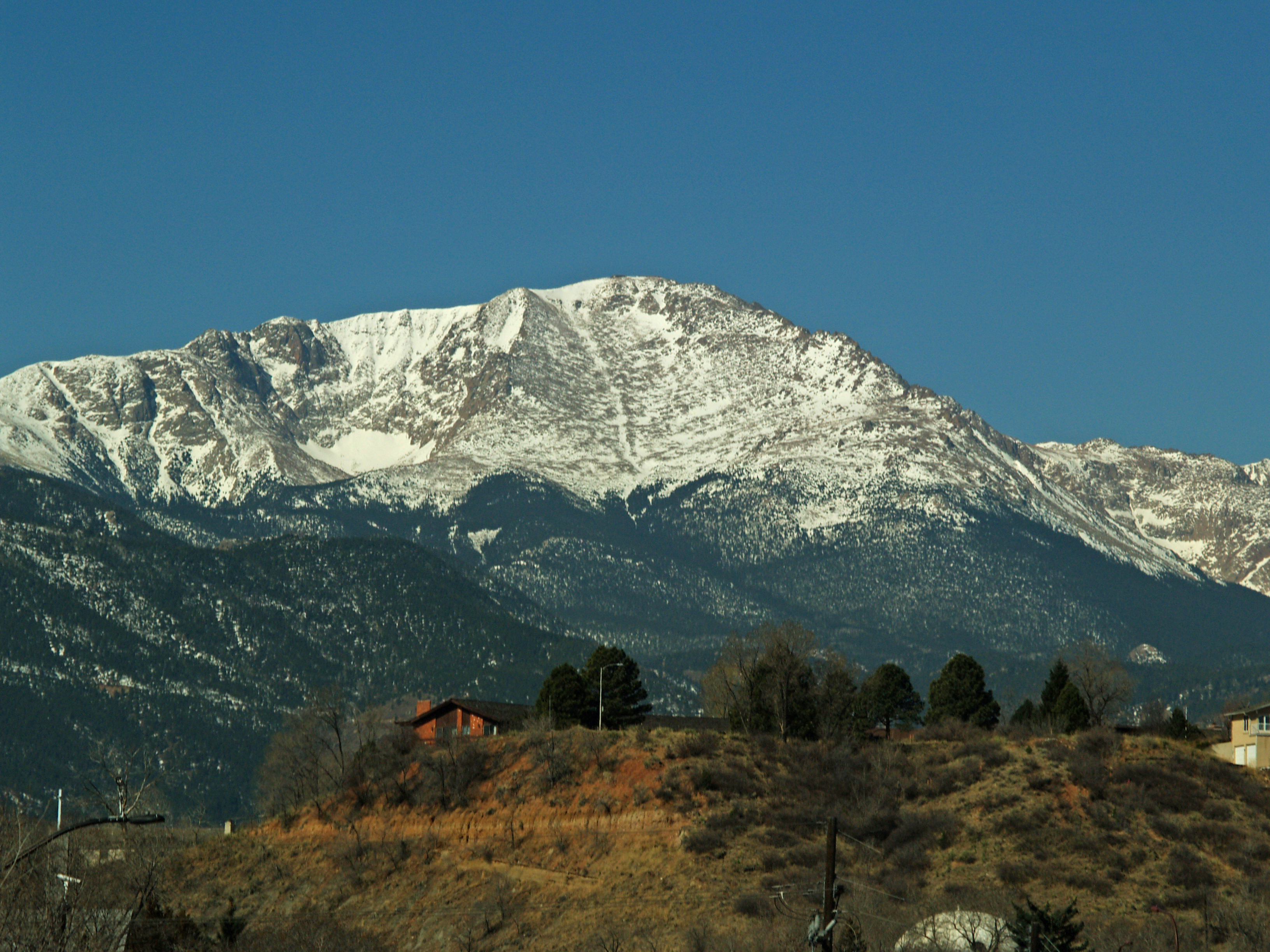
Pikes Peak is pretty well known even outside of Colarado, and at 14,115ft the summit is higher than any point in the US east of its longitude. It is named after https://en.wikipedia.org/wiki/Zebulon_Pike)
who other than having a really cool name eventually became a Brigadier General for the early United States Army and died in combat during the War of 1812. In 1806, at the age of 27, he was ordered to explore, map and evaluate the headwaters of the Arkansas and Red rivers. So off he went on what is now known as Pike Expedition and in November he and his team saw and tried to climb to the summit of what they called Highest Peak. He never made it to the top, noting in his journal:
“…here we found the snow middle deep; no sign of beast or bird inhabiting this region. The thermometer which stood at 9° above 0 at the foot of the mountain, here fell to 4° below 0. The summit of the Grand Peak, which was entirely bare of vegetation and covered with snow, now appeared at the distance of 15 or 16 miles from us, and as high again as what we had ascended, and would have taken a whole day’s march to have arrived at its base, when I believed no human being could have ascended to its pinical [https://en.wikipedia.org/wiki/Sic “Sic”)]. This with the condition of my soldiers who had only light overalls on, and no stockings, and every way ill provided to endure the inclemency of the region; the bad prospect of killing any thing to subsist on, with the further detention of two or three days, which it must occasion, determined us to return”
Lucky for me there’s now a trail (not to mention a road and a railroad) and I’ll be going in June, not November so hopefully I can avoid the waist deep snow, the below zero temperatures and the outlook that no human being could have ascended. I hope my run goes a little more like the first recorded summit, which was in the summer of 1820 by https://en.wikipedia.org/wiki/Edwin_James_(scientist)) and two others who left an expedition and reached the top without incident during a two day climb with little difficulty.
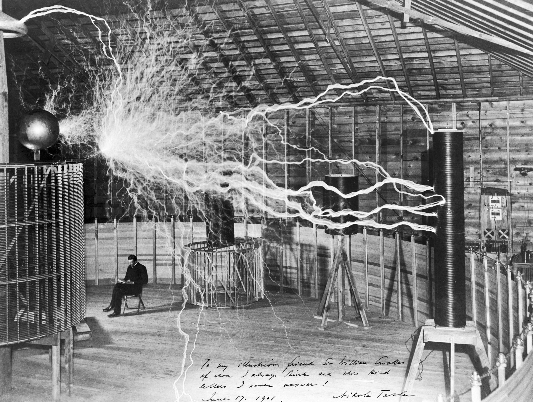
Pikes Peak became popular during the mid to late 1800s gold rush (as did the phrase ‘Pike’s Peak or bust’) but mostly because of it’s visibility, not for any significant amount of gold found near the area. In 1893 https://en.wikipedia.org/wiki/Katharine_Lee_Bates) wrote the song “America the Beautiful” after admiring the view from the summit. And during 1899 https://en.wikipedia.org/wiki/Nikola_Tesla#Colorado_Springs) lived and studied high voltage/high frequency electricity and wireless power transmission in the high elevations near Pikes Peak. It was in his lab out here that the famous picture below was taken by a magazine for publicity – don’t be fooled though, it is a multiple exposure image, he didn’t really sit there while the electricity was discharging.
There is also a cog railway that climbs to the summit and has been bringing tourists up the mountain since 1891:


And in 1918 https://en.wikipedia.org/wiki/Fred_Barr) built the https://en.wikipedia.org/wiki/Barr_Trail) now named for him that goes to the summit. He built it to help his burro train business and also established Barr Camp about halfway up to provide an overnight stay for hikers wanting to make the summit in a two day climb. Both the trail and camp are still operational today (no burro trains though) and this is the trail I plan to run up.
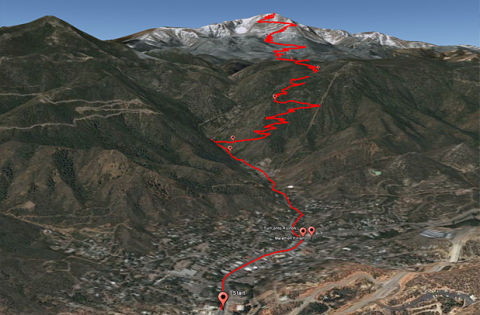
The idea to run it rather than hike it came from reading about people who didn’t settle for just hiking up the trail in two days, or even one but instead decided to run a marathon up and down the mountain and established the http://www.pikespeakmarathon.org/) in 1956. The race has taken place annually since 1966 for those crazy enough to want to run up and down the mountain in a few hours. Soon I’ll be at least half that crazy. Below is a picture of Barr Trail and the marathon course through the nearby town of Manitou Springs.
This all sounded great to me, and the picture made it look even cooler. A 12ish mile run up a mountain known for great views that served as the inspiration for the song America the Beautiful is right up my alley. But there are some things to consider…
Potential Problems
The first and biggest issue is that Pikes Peak is a mountain. I don’t think I’ve ever been above 5,000ft elevation (outside of a plane) – and that’s generally where people start to experience the effects of higher altitude. The Barr Trail starts at over 6,000ft and climbs to over 14,000ft. The air at the summit contains roughly half the oxygen of air sea-level and can cause shortness of breath, nausea, fatigue, weakness, headache, lightheadedness, nose bleeding, rapid pulse, pins and needles, general malaise and flu like symptoms. Also, dehydration happens much faster than at sea-level. None of that sounds very good for running and there’s not much I can do to prepare for the elevation other than going to elevation. The best thing to do is hope for is my body will gain some acclimatization over the few days I am in Denver before heading to Pikes Peak and keep an eye out for the more serious symptoms of altitude sickness. I will need to bring my own water so I am looking into hydration packs.
Another issue with running up a mountain is weather. The base and summit can have temperature differences up to 50º F. That picture with the train and the snow above was taken in May. The 2004 marathon, which takes place in August, had to deal with 6-8″ of snow on the Peak and thunderstorms are very common, especially during the summer. The typical high at the summit in June is 38º F compared to 79º F for nearby Colorado Springs at a similar elevation to where I’ll start the run. This shouldn’t be too hard to deal with but I’ll have to make sure my hydration pack can fit some colder weather gear and get used to running with a backpack.
A further concern is the climbing itself. The trail gains almost 8,000ft of elevation in just under 13 miles with an average grade of 11%. A big steep hill during a 10km run that I’m used to might be 11% grade, but it will also only be about 1/4 mile. The race website says the ascent takes about as long as your flatland marathon time if you live at altitude, and anywhere from 1/2 hour longer to 1.5x your marathon time if you are a flatlander. Since I am definitely a flatlander and don’t have running up mountain experience I’ll have to tailor my workouts leading up to the run to help me prepare. Of course that will be a little hard because the highest point within 2 hours of me is 400ft and one of the closest hills I can easily run up has an 11% grade which is good, but is only 1/10th of a mile. To compensate I’ll have to add hill repeats and maybe even treadmill running at incline to my weekly routine.
The Plan
Going into something like this with a realistic goal to help guide your training is a good idea and can help plan your training and motivate you when it’s rainy and you just don’t feel like going for a run. For me, the ultimate goal is to finish the climb with an added goal of a time around 4.5 hours. I’m starting with a conservative 4.5 hours as a goal and depending on how training and altitude feels I will adjust that up or down. I’ve got 7 weeks of training to prepare and I’m pretty confident. I’ll be updating this page with my efforts throughout including a closer look at my training and a “race report” after I finish.